Record breaking warmth won’t stop winter
November 28, 1990
Although record-breaking temperatures and heavy rains pounded the northern Illinois area Tuesday, winter should be here this weekend.
Dale Helgerson, a forecaster with the National Weather Service in Rockford, said the mercury climbed to 65 degrees early Tuesday morning, surpassing an old record of 62 degrees set in 1960.
But “there’s a pretty good cold front in our vicinity,” Helgerson said. “There’s quite a contrast on either side.”
The system extends from southwestern Michigan across Illinois and southwest Missouri and reaches Texas, Helgerson said. The front—past Michigan by now—is delivering the unseasonable temperatures and rainfall while the back only drops light rainfalls.
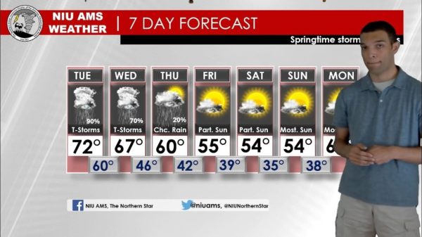
Normal temperatures for this time of year are highs of 40 degrees and lows of 24. As the system continues moving east, temperatures should begin dropping to those levels—probably by today, Helgerson predicted.
Helgerson said low pressure fronts climbing through the system are bringing the downpours. By 5 p.m. Tuesday, more than 1.2 inches were dumped on the area and more showers were expected during the evening.
While conditions like those of Monday and Tuesday aren’t normal, “it’s happened before,” he said.
But the conditions should be a memory by this weekend, when forecasters expect no precipitation and near- or below-normal temperatures and the area should be on its way toward winter.
The storms were at their heaviest late Tuesday afternoon when the National Weather Service began issuing tornado watches, which Helgerson said, should have extended until 9 p.m. However, the watch was cancelled at 6:22 p.m.
A tornado did touch down in nearby Geneva, Geneva Fire Department officials said. There was some damage and downed power lines scattered through the city, the spokesman said.
Also, the Peoria weather service reported seeing a funnel cloud.