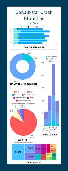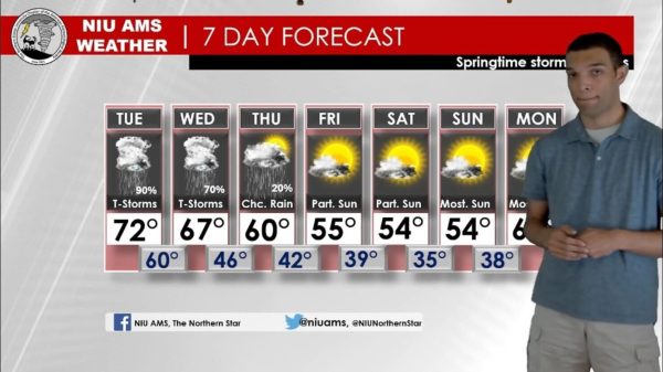
Spring-like weather falls into DeKalb temporarily
November 19, 1991
NIU students and DeKalb residents cannot expect Monday’s spring-like weather to last.
Ron Fields, forecaster for the National Weather Service, said yesterday’s high of 65 was because of a strong, high pressure off the eastern seaboard and warm air off the Gulf of Mexico. With the warm air comes moisture, Fields said.
“The good news is that the moisture will be liquid, not snow,” Fields said.
“The last time it was quite this warm was around Halloween,” said Adam Miller, senior meteorology major.
A string of warm weather at the end of October brought highs in the mid 70s, Miller said.
Fields said to expect rain beginning Wednesday evening, with highs in the 50s and lows in the 40s.
“There will be a cooling trend beginning on Thursday,” Fields said.
The expected cooling trend is a result of a dry, cold front coming down from Canada and an expected wind shift, creating a strong system, Fields said.
Thursday and Friday’s highs are expected to be in the lower 40s. Temperatures on Saturday will be highest in the morning, and gradually falling. Light rain or snow will fall Saturday, Fields said.
“Saturday might be the first significant snowfall this year,” said Tim Bowers, senior meteorology major.
Today will be partly cloudy with expected highs in the 60s, but it will cool down from then on and remain in the normal weather pattern until Saturday, Bowers said.
The NIU weather report hotline is available 24 hours a day at 753-1623 for getting a full weather report.